Packrafting the Caples River in a more exciting manner!
A picturesque lunch in the mountains
Map of Route
My Trip
(Note: This blog is large and to save space, images are in sliders. When viewing images – Click on an image to zoom in, but note that captions only show on non-zoomed images)
06/11/2021 ~ 07/11/2021
Introduction
The weather window was amazing, and with only a weekend to spare, I had to make the most of it. I decided to do a solo packrafting trip, but wanted to make it more epic and not all about the packrafting. Whilst I had done the Caples River before, it was a logical choice for a solo raft, as it is quite forgiving if things turn pear-shaped. So, the Caples River it was!
I then decided to tackle heading from the Scott Creek Track, over the Humboldt Range and down into Kay Creek to get to the Caples River. Topping on this, why not add biking in too? It all came together!
Day 0 – Arrival and bike drop-off
After finishing work on Friday, I drove my van 1.5 hours to Greenstone carpark, where I would finish the packraft. Here, I chained my E-bike to a fence, and then drove back up the road to the Scott Creek track carpark, just off the Routeburn road turn-off.
I was hoping to head up a short way to tent camp, but it was already 6:30pm, so I slept in my van and decided on an early start in the morning.
Day 1 – Scott Creek Track carpark to Kay Creek valley
Being mostly pre-packed help start the morning off. With a nice coffee and breakfast down in a matter of minutes, I had started the trail. It was 7am, with a rising sun.
I made my way through the sheep paddock, and managed to find the fence stile to get past the fence. In moments, I was venturing into beech forest.
The beech forest continued at a moderately steep incline, with the sun opening up and warming the forest with its vibrant rays. It was truly beautiful and all felt good! I passed the first clearing (marked on the map), and noticed it was quite a decent area to camp. I probably could have made it there the previous night in hindsight, but it would have been limited light.
Once I breached the beech forest, the marked trail ended. A lovely clearing that would have made a good campsite presented itself. I had some morning tea here, including a coffee.
Now, it was time to start the off-trail section, following the small stream coming off Scott Creek Basin.
Continuing to follow the small stream, I started making my way across the edge of Scott Creek Basin, and up towards the pass. Scott Creek Basin was fairly rugged and mostly with thick low tussock, rocks and scrub. Plenty of camping options all the same.
Heading up from Scott Creek Basin can be done in several ways around Peak 1552m. I chose to go to the far side (on the right), however, it would not matter which way. At above 1500m, the snow started appearing. I passed a small tarn, strikingly blue in appearance, before getting a little higher, where the larger tarn was visible.
I crossed the outlet of the tarn, where beautiful blue water was pooled, before being discharged off down towards what would become Kay Creek.
It was here I first noticed a second set of snow prints from someone else. They appeared fairly recent, and headed to the far left of the pass. I decided to follow them, as they were going on a similar path I had planned to take.
On top of the 1700m Pass
The climb up was fairly straight-forward, despite being slow and steep. Here, I had a lovely lunch of tea, biscuits, cheese, salami, and sun-dried tomatoes – all whilst using my packraft gear as a seat and table.
After lunch, I began the descent into Death Valley. I decided to continue following the other footprints to see if I would bump into another adventuring human on the way. The snow by now was quite soft, and I began deep post-holing (legs sinking into snow) in sections.
There was a nice steep slope with a long run of snow, so I decided to glissade on my butt for some fun. It’s always worth it!
I reached the tarn, still partially iced over, at around 1:40pm. Perched above the tarn was the mysterious other adventurer whose tracks I had been following. He was a Brazilian guy around my age, who had camped back over where I came from above Scott Creek, and was just on a day trip before he returned to his tent camp.
After making my way down a steepish tussock slope between 1400-1250m elevation, I began following the small creek in Death Valley.
The day had been hot, and I decided it was a perfect time to have a swim, so I stripped off, and embraced the fresh cold water!
After the swim break, I once again continued on my journey deeper into the valley below. Here, the vegetation thickened as I left the alpine region behind. There was a rough trail making its way down the true left of the creek all the way down to the hut.
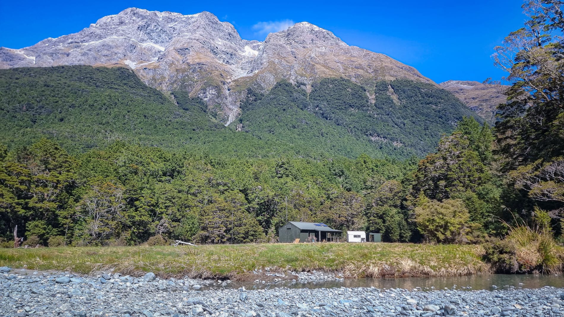
Not long into the forest, around 3:40pm appeared Kay Creek Hut. This was a pretty basic 4-bunk hut that has been around since 1960 with only some restoration work done in 2016. I thought about staying here, but I preferred to find somewhere to tent camp.
The Kay Creek track was fairly easy and straightforward to follow. There was a creek crossing around the 850m contour. I found it a little easier to cross a bit further downstream.
The day was growing late, and I was needing to find a suitable tent site. The first part of the clearing on the topo map was not very flat at all, and I found myself needing to continue on further. The only decent spot was (on the top map) below the ‘C’ on the creek label.
Camp
The sandflies were in full force here, and after making the tent, I found myself stretched out – feeling tired, but super stoked from the great day! It was time for a swig of rum and a hearty feed of Mi-Goreng noodles, dried shallots and peas! I can’t remember much after this, so I must have slept haha!
Day 2 – Kay Creek to Scott Creek carpark via the Caples River and Greenstone Station Rd
Breakfast the next morning consisted of some delightful gourmet ‘oats spectacular‘ – basically: rolled oats, coconut, dried cranberries and sultanas, cinnamon, sugar, and milk powder. I ended up leaving at 8:45am, on my way out the Kay Valley.
The morning walk in the beech forest was lovely and pleasant. The track along the entire Kay Creek valley was in pretty decent condition for a fairly non-popular route.
An hour and a half later, I reached the Caples River. The hiking section of my trip was done (or so I thought at the time!).
Converting from hiking to rafting is always rewarding. Your legs get a break, and your arms take over the hard work – the perfect work out combo! Once my raft had ‘ingested‘ my pack and gear inside, and sucked in some air – the river was calling my name!
The upper Caples River section is a little boney (shallow), and required a few walks over some shallow sections, along with one or two fallen trees to get around.
Around the 410m contour, the Upper Caples section closes in to a small gorge with Class III rapids. I’d definitely give this short gorge section a go in a group, but not solo. So, alas, it was hike rafting time. I decided to just skip the 1km easy section between the two gorges, as it was far from the trail anyway. I ended up hiking with my raft over my head for 1.5km instead of deflating and repacking into my hiking pack. With a few needed arm rest breaks, I managed to reach Mid-Caples Hut at 1:20pm for lunch.
From here, I took the bush track on this side of the river that heads out above the grassy bluff section, where a ramp enables you to progress down to the lower section, and towards the lower exit of the main gorge.
From here to the car park I had paddled before in early 2020 at the PRANZ Packraft meet up in Queenstown 2020, so I felt comfortable knowing what was coming up.
I paddled against the slow flow easily, into the stunning gorge. Here, the water radiated a vibrant turquoise and aquamarine colour – it was truly stunning. I paddled through the pack as far as I could before the flow narrowed, steepened and turned into rapids, before turning around back out the gorge.
The section below the gorge is quite relaxing, with a few fun play waves and occasionally, some narrow chutes. The water here is a bit deeper, and getting caught out on the boney sections isn’t as common as it was in the upper section. This is the sweet spot for anyone looking for an easy, relaxing paddle, that throws in a few cool, easy rapids to play on.
After the Greenstone River Confluence
After the Greenstone River confluence with the Caples River, there are about 3-5 notable rapids that hit the Class II+ mark (with one rapid maybe reading III- in high flow). They are all pretty forgiving with consequence, each with a pool of slow water to recover in, and all portagable.
Before long, at 3:40pm, I was sailing under the Rere Lake bridge and nearing the carpark, where the Caples River packraft section concludes.
Once at the carpark, I was immediately quizzed by a local family looking to get into packrafting. We talked for around 10 minutes about the sport.
I then began the reverse process of turning the raft into a backpack. *unziiiiiip*…. *phhhfffffssssshhhhh*, as I began to disembowel the contents, before neatly arranging them back into a suitable carrying order, ready for the long ride ahead of me.
The Ride back to Scott Creek
This was the first time I have ever ridden with a pack, and I definitely learned a thing or two about not having enough headroom to lift my head back, and how corrugations on the road reaaaally hurt your ass after a while. Nevertheless, I persevered, and smashed out the ride along the road, fords, all whilst surrounded by gorgeous views!
One of the highlights of the ride was undoubtedly following a sheep running on the road in front of me. It manically was trying to escape me (yet futilely running in a straight line forwards), all whilst spraying brown seeds of goodness in its wake out of sheer terror, right before throwing itself against the fence (rather than over) as a last desperate manner of escaping the crazy bike-man! I felt bad for the sheep, and by no means meant no ill-will against it, but it still was hilarious.
In order to support the travelling and hiking community, I spend many hours per week or month to adequately document all information and advice for prospective visitors, accompanied by a (hopefully) entertaining insight into my personal experiences. This service is, and will remain, free. However, running a non-profit website and spending time creating content comes with financial and personal costs.


Great story, thanks for sharing
Cheers Richard! 😊 Thanks for reading!
what a beaut weekend, the rafting in superb scenery. You came away with some choice shots Matt.
Cheers Eddy! The weekend couldn’t have been at a more perfect time!