Ivory Lake via Hokitika Gorge & Whitcombe River – New Zealand: Multi-day Hike

From Sea Level to 2136m! An Alpine Adventure for the Tough Adventurer!


Navigating knife edge ridges in low visibility

Map of Route


Hike Information

Location

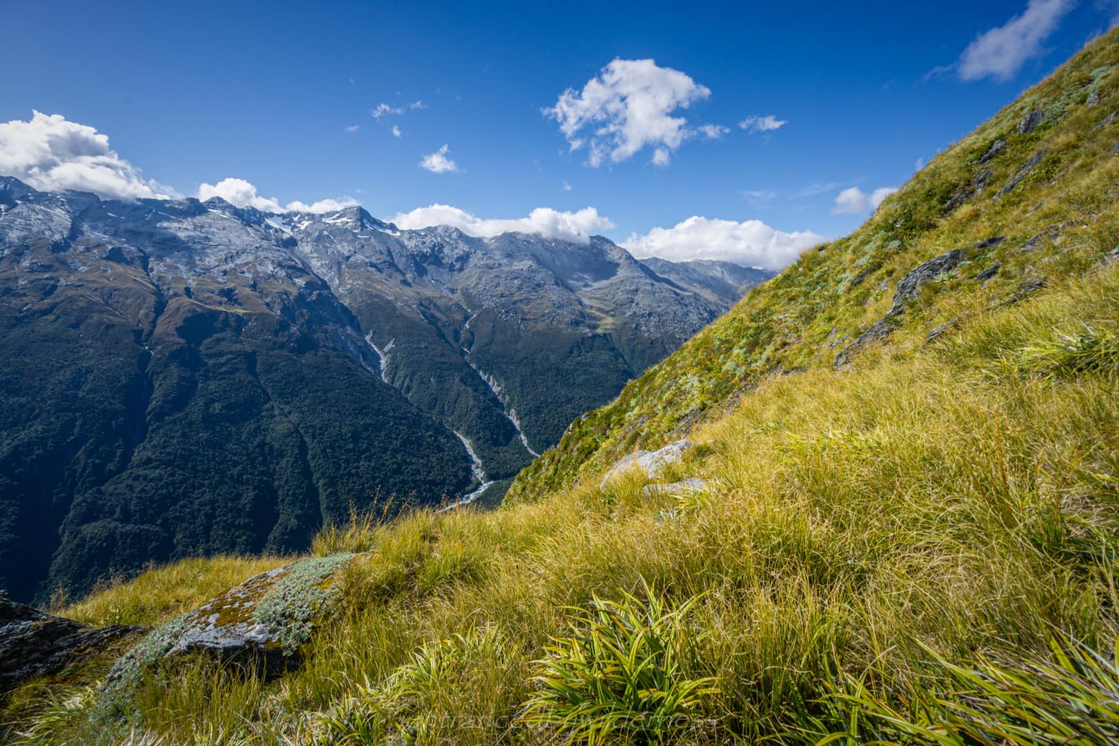
West Coast of South Island, New Zealand, near Hokitika. Access via the tourist attraction—Hokitika Gorge. 

When to Hike?

Late Summer—Early Autumn

Avoid the snow in the tops at all costs, and Spring’s higher level river crossings.

Length of Hike

5-8 days, depending on hiker. The length is approximately 90km, with 4300m of elevation gain in total.

Experience Level

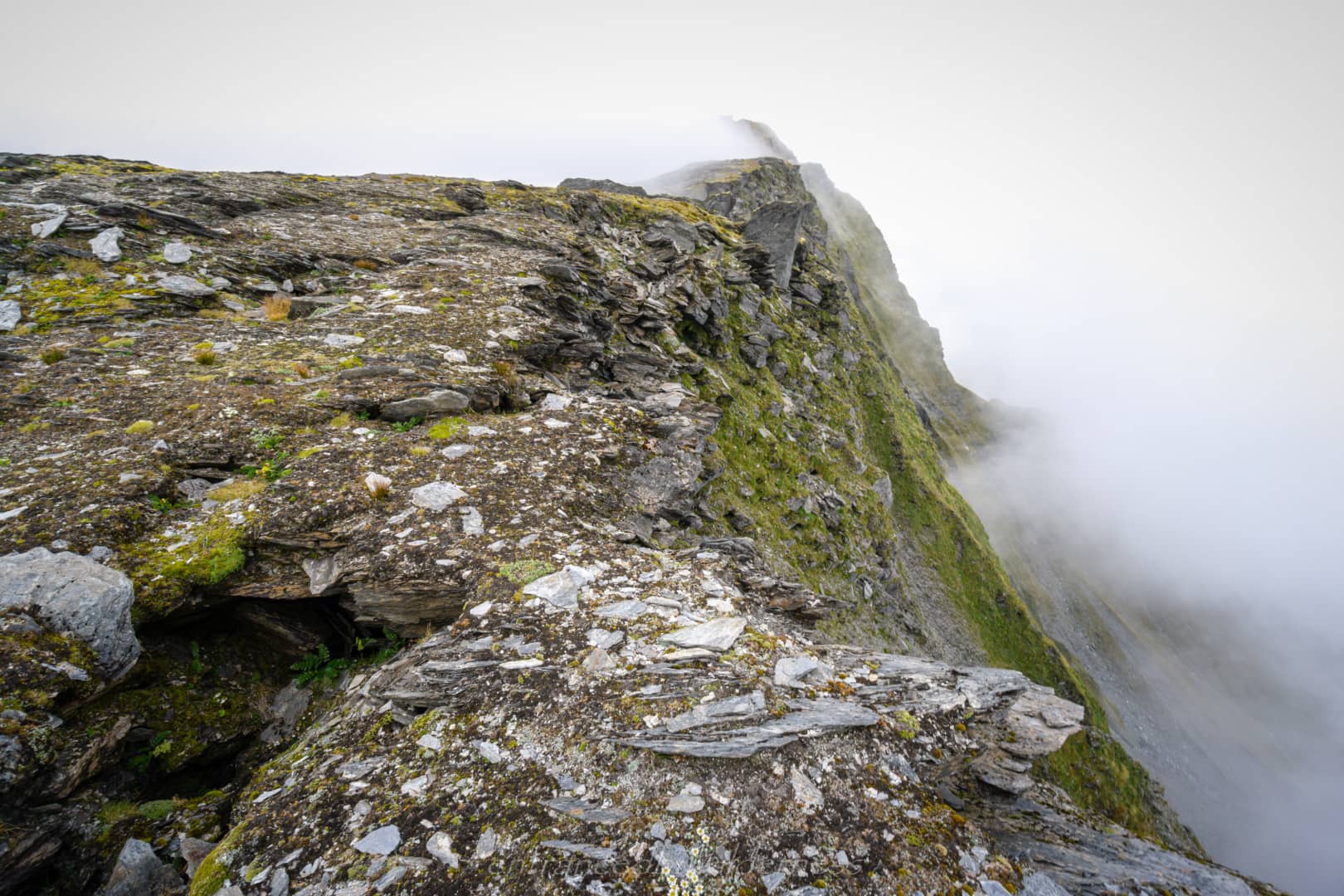
The Ivory Lake route here is aimed at experienced hikers who have at least one party member with navigation and snow skills. GPS navigation using an offline topo map is ideal, along with backup paper maps/trail notes. Ensure you’ve done recent research for this route, as the terrain changes every year, including forecasts and avalanche risk.

Camping

There are a few huts on this route, and you could aim to only use huts for the whole trip. These huts include: Explorer Hut, Healey Creek Hut, Ivory Lake Hut, Price Basin Hut, Price Flat Hut, Frew Hut, and Rapid Creek Hut. Camping options vary in different sections, but generally, there are good camping options in most areas of the hike. Snow patches in the upper ridges allow for water sources – as there are limited tarns.

Trail Overview

Please note, the below trail suggestions are intended for describing conditions outside the winter season.

Terrain Type:

  1. Flat
  2. Mostly flat with some hills / moderate climbs
  3. Hilly with moderate climbs
  4. Hilly with steep climbs
  5. Consistent steep climbs

Trail Condition:

  1. Path, marked
  2. Graded trail, marked
  3. Rough trail, marked
  4. Poor or neglected trail / partially marked route
  5. Unmarked / no trail (backcountry)

Experience Level Required:

  1. No hiking experience needed
  2. Some hiking skills recommended
  3. Hiking experience required (some potentially dangerous terrain)
  4. Good hiking experience required, with navigational needs and potentially additional safety equipment
  5. Mild-mountaineering. Strong hiking experience / additional safety equipment required for dangerous terrain
  6. Technical Climbing. Only experienced professionals should attempt

Important Notes:

  • Technical knife-edge ridge traversing is present in areas, with an exposed and difficult crux section (read below, under Galena Ridge)
  • Potential river crossings for solo hikers, or when cable-way is not functioning. Not suitable to hike with flood-water in general.

My Trip

08/02/2023 – 13/02/2023

Introduction

Ivory Lake has been an enticing destination for many years, and I’ve just never been able to fit it into any schedule successfully. This seemed like a perfect time to undertake the challenging route.

I had researched a few different trip ideas, but none were great as a loop, which is always my goal. The route I ended up choosing was not the easiest, but it offered good loop potential. This was the one using Hokitika Gorge as both the start and finish of the trip. There were two different ways I considered going after Ivory Lake and decided the Price Basin route was the best option (the other being backtracking to Steadman Brow). 

Day 1 – Hokitika Gorge to Minnow Creek

Hokitika Gorge and River

I had arrived quite late in the day to Hokitika, and didn’t start hiking until 5:30pm. The plan was to just get as far as I could in the day and camp there. 
The journey began on the spectacular Hokitika Gorge Track. The vivid blue waters of rivers in New Zealand never cease to captivate me. The trail continues along the true left of the river (not yet updated on all topo maps), as it’s quite new, before looping back via a second footbridge. At this point, I left the main trail, hiking past the sign and footbridge to remain on the true left side, before dropping to the river below.

On the topo map, it shows a trail along the river. This doesn’t exist, and instead, the river shore needed to be followed. Occasionally, I needed to venture into the bush to get around parts where the river chokes the bank, or boulders are in the way. The bush is full of supplejack vine, and very tedious to gain distance in, and returning to the shore was relieving!

Minnow Creek

Once passing Minnow Creek, I began to see old trail markers, and a rough passage up the true right of the stream. Here, there was a decent rough trail.

When I reached the flatter 240m elevation point about the steep climb, the night was looming upon me. I decided to camp here by the creek at 8:45pm.

Day 2 – Minnow Creek to Healey Creek Hut

The goal today was to get to Healey Creek Hut, which would be quite a big day. I set off along Minnow Creek, which became the path I’d follow, as there is no trail here.

It was mostly straightforward, although I had followed a side stream that led me toward the marked saddle on the topo map, and not along the main stream (it’s not apparent). It wasn’t a big issue, but there was one part where the vegetation boxed me in. Here, I crossed a deer path and took that instead to rejoin the trail in Surveyors Creek.

Once I reached Surveyors Creek, it was much more open and easier.

Doctor Creek & Explorer Hut

Surveyors Creek shortly converges with Doctor Creek. Here, I headed upstream toward Douglass Saddle and Explorer Hut. Doctor Creek has numerous sections, such as Smith Gorge, where the trail took me up and around the steep gorge sections. The trail was fairly easy to find here. However, when I reached the split of Doctor Creek and Vanina Stream, I didn’t see the trail marker leading up the spur leading to Explorer Hut. I ascended via Doctor Creek side, but I think the access is actually via Vanina Stream. It was an awkward scramble up to gain the spur!

Once I neared Explorer Hut, the trail became more of a trail. I ended up arriving around 12:45pm. The hut itself is just in the middle of the forested saddle – nothing too special, but it’s in good condition for an overnight stay! I had lunch inside to escape the sandflies, and set back off toward the Mikonui River. 

The route from Explorer Hut down to the early reaches of the Mikonui River was decent trail. However, hook grass was dominating the trail and it literally covered my legs! UGHHH! 

Mikonui River

Once reaching the Mikonui River, it was time to head downstream about 4km. This section was fairly open and easy to traverse. 

Thankfully, Permolat had done some recent track and hut work in this region. The new signs directing towards the huts on the spurs were easy to see. After passing the sign towards Mikonui Spur Hut, I reached the Dickson River. I could see the Dickson River crossing being a problem in high flows, but for my crossing, it was easy enough.

Healey Creek Hut and Ridge

Eventually, at 4:15pm, I made it to the Healey Creek track turn-off. The trail here heads steeply up 1000m to Healey Creek Hut. The trail was easy to follow and well-slashed. 

Once on the narrow exposed ridgeline, I could see panoramic views all around the various valleys and peaks – it was beautiful! I also received a visit from a curious Kea, landing only 1m away! Such majestic birds!

It was growing late, but thankfully – summer daylight hours! I arrived at Healey Creek Hut at 7:30pm. There is no natural tarn or stream at the hut, aside from soggy marsh, so the water tank is the only real source here without walking far.

Inside, the hut was recently maintained, and quite cosy! I immediately prepared a well-deserved dinner – an attempt at something resembling nachos!

The weather was quite good at this point, but I had enough reception to see that there was rain forecast for early tomorrow morning.

Day 3 – Healey Creek Hut to (near) Mt Beaumont 

Although I had gotten up early and was packed ready to go by 8am, the rain made me hesitate. It was meant to rain overnight, and clear up in the day. However, the clouds were meant to remain all day. This was a problem as I was literally traversing the highest parts of the entire trip on this day. 

I waited until 9:30am, the rain had mostly stopped, but the clouds were still just as thick. I decided to just go ahead and see how I would go. 

The first section of the day was climbing up towards Galena Ridge. This was a fairly tricky exposed section to follow a knife-edge ridge for 2km. I had found the initial section easy enough, but the section near peak 1643 was a challenge! It felt logical with the terrain to head up to the peak, but it would actually have been easier to sidle around the 1520m contour. Peak 1643 is actually not too bad, but the section after before the ridge is where it’s difficult (where the lower contour kinks inwards). It’s exposed with no traction or hand holds. It took a lot of careful movements to descend (even though it looks flat on the contours).

Galena Ridge

Once on Galena Ridge at 12pm, hiking became easier! This is a broader ridge with a lot more options. I had lunch here in an area that can only be described as ‘like Mars’. It was pretty cool actually!

Shortly after lunch, at around 2pm, it started raining. I already had the appropriate layers on from lunch and was undeterred by the rain.

Peak 1974 had some crazy landscapes and a few patches of glacial remnants.

Crux Section

All was going well until I reached the narrow crux point between peak 1974 and peak 2001. One thing the map doesn’t show in this entire region is just how much of a knife edge these rocks make! And when I say a knife edge here, I mean a KNIFE…. made out of weetbix!

In this section (just after the lowest point on the ascent at the 1920-1940m contour), I had approached from the west side of the knife edge, but needed to cross to the east side. There is no way to continue on the west side as far as I could see, and I had tried climbing higher to cross further up, however, there was just no way I could see. So, I retreated to the original logical crossing point.

Here, I had stowed my poles, and took deep breaths with every moment, hugging the crumbly ‘weetbix’ rock and trying to be as light as possible with the limited and sloped footholds. There was nothing to grab hold of, and a fatal 250-300m fall, straight down with any error. It didn’t help (or did it?) that I couldn’t see below me.

In all my life, I have never been so focused – making each movement with a careful and well-considered approach. All in all, it only took about 4 steps to make to get past this section, but they are the most important steps I’ll ever make! Definitely, the most dangerous thing I’ve done in life!

Mt Beaumont

After the crux section, the terrain was far more accessible. Climbing up Mt Beaumont was steep, but fairly easy. I arrived at the summit around 5pm, the highest elevation of the entire trip at 2136m. Here, the tops of Mt Beaumont were partially glaciated, but you could get over the tops without even touching snow. There was a nice ‘ramp’ leading off the top towards the southwest ridge. I navigated this with ease with barely any visibility.

I had reached the saddle at point 1878 on the topo map – halfway between the two highest peaks of the whole trip. It was 5:45pm, and I decided to not risk heading any further with the poor conditions. I was pretty soaked from the rain, and there were no guaranteed flat sections to camp after. Ivory Lake Hut just looked too far to reach with the limited daylight hours remaining. 

I quickly set up my tent in the rain, gathered some snow for water, and changed into some dry clothes. One of the most amazing feelings is laying in the tent all dry, warm and cosy after a hard day!

Day 4 – (near) Mt Beaumont to Price Basin Hut

The next morning, I had awoken to clear skies and sunlight beaming through my tent! It was glorious after the miserable weather yesterday! Coffee and breakfast, basking in the sun’s rays – what a way to start the morning! I packed up and was ready to start hiking again at 9am.

The first section of the day was ascending 200m to Peak 2084m. This was initially easy, but dropping off the 2020m contour before the peak was a bit of a challenge. The crumbly weetbix schist just offers no real stability.

Peak 2084m (above Ivory Lake Glacier)

At 10:30am, I made it! The summit of peak 2084m was a great vantage point to look back towards Mt Beaumont, where I had come from, and also towards Ivory Lake and the way up the slopes of the Lange Range.

Ivory Lake, Glacier & Hut

Ivory Lake was stunning! As I descended from peak 2084m, I was amazed at the beauty of the surrounding views. It truly was rugged but breathtaking country out here!

The route down wasn’t too bad, the only notable challenge was the gap before peak 1620m. I came up the direct north side, but I’m wondering if sidling around the west would have been easier. A descent here would be more challenging.

My final obstacle before the hut was crossing the lake outlet. The rock is very smooth here, and the most accessible place to cross the outlet was at the lake’s edge.

When I arrived at Ivory Lake Hut at 1:20pm, I found there was a group of elderly hikers who had just arrived not long before. They were planning to stay the evening at the hut. They were doing a loop via Waitaha River and the Tuke River.


Lange Range

After farewelling the other hikers at 2:25pm, I made my way towards the Lange Range, Here I would climb the 650m of elevation up to Peak 2056m.

The initial section up the wet mossy waterfall section was tricky to get good traction purchase sometimes, but after, the ascent was straightforward.

After the 1900m contour, the terrain relaxes slightly, and opens up to large patches of glacial snow. It was pretty slushy, so I ended up using my crampons for the first time, even if only for a short traverse. 

The views toward Ivory Lake from this angle were amazing! Once at the top around 4:30pm, I could now see into Price Basin, and the ridge I’d be following.

The initial obstacle was a little tricky – a small glacial section of snow right under the peak. It took some careful steps to ensure a slide wasn’t on the cards. Once the step part ended, the snow was easy and began to subside.

Mt Wylde Brown Ridge

The section after the glacial snow is where things, again, got tricky. The ridge closes in and becomes more solid and condensed, with huge rock protrusions sticking out from the ridge.

Keeping to the main ridge, I found myself at the 1920m contour, having to head more northward, as the ridge drops off sharply (not shown on contours). And again, just below 1900m, I found myself caught out above an awkward drop-off. This one required some precarious shuffling and steps to get down.

When I looked back, I felt like the steeper southern side of the ridge would have been better, with fewer large boulders to navigate over or around.

The final section was a narrow bridge of scree (the skinny section on the topo map). This wasn’t too bad to cross, however.

Once at the 1830m contour, hiking becomes easy. It was about 6:30pm, as I began progressing down the ridge leading to Mt Wylde Brown. I was thinking about where I should stay for the evening, it was quite nice on the ridge, and there were snow up high, or tarns down low for water.

I decided to push on to Price Basin Hut though, more so because of falling behind my schedule due to the bad weather before. 

Price Basin Hut

I remained on the true ridge until around 1600m elevation, where I changed course due South-East, and made way down a spur leading into the basin. There is no real way down before this, due to the nature of the terrain being filled with slips. Initially I was following cairns down, and it was straightforward. However, I lost them (despite remaining on the spur), and found myself in thick, gnarly scrub towards the lower sections. Every step was either speargrass, or an unseen hole. It was the SLOWEST and most tedious section of vegetation so far on the trip for me – probably also because it was growing dark and late!

I arrived at Price Basin Hut, only to notice there were two other guys there already. They had helicoptered in for a 5-day-long hunting session (and were getting picked up the next morning). ‘Lazy hunters!’ I thought, after climbing over all those mountains to get here!

They had told me in their time spent here, they found it easiest to access the ridge I came down via the creek bed (I think they meant the one leading up from the south side of the hut). They shared some bacon with me, which was AMAZING… and we shared stories of our trips, despite being here for different purposes.

Day 5 – Price Basin Hut to Price Flat Hut

The chopper came in, early on, to pick up the two hunters. I was once again alone in the remote wilderness. It was 8:30am, and I allowed a deep, refreshing breath before starting my journey.

The hunters had told me the track heading up Pahlow Ridge didn’t really exist. They had scrub bashed to head up. I decided to tackle heading up the steep creek section. It seemed like a good idea initially, but getting out of the top section below 1140m was quite challenging with all the loose stones.

In my haste to push on out of the creek, I forgot to collect more water. This didn’t feel like an issue at the time, but I didn’t realise there would be no water for many hours to come. I thought I would find at least a trickle on the next stream marked on the map, but it was dry. 

Thankfully, nature provides! The Mount Cook Lillies had water-catching leaves to sustain small amounts of water for me the whole time.

Pahlow Ridge

The entire way up to Pahlow Ridge was battling through rocks, tall tussock, and of course, speargrass. It was not an easy morning hike, that’s for sure! Once on the ridge, I then needed to descend to Johanson Peak. It looks like you can sidle under on the northern side, but it’s quite steep! I made it here around 11:30am.

The marked track doesn’t exist at all in this whole area. The next sidle was more of the same – tall tussock and speargrass. There was a little trickling stream below the bluffs, which was refreshing after sucking from lily pads all day!

After the sidle, I had some lunch before the huge descent before me. Ahead, below Mt Van Redan, I could see the creek that the ‘supposed’ trail was meant to follow, all the way down to the Whitcombe River.

The Creek Descent

As suspected, the trail didn’t exist. It WAS the creek. Initially, there was no water, but not far into the descent, the creek built up flow. 

This was not an easy descent by any means. Often, there are drops and huge boulders to traverse around. Sometimes, some bush bashing off to the side is required, with the most notable one being around the 820m contour, with a giant boulder drop-off. Perseverance and allowing time were the key here!

Whitcombe River

At 4:45pm, I had FINALLY reached the Whitcombe River. Here, I was thinking I’d be able to simply cross it, and rejoin the Whitcombe River Track downstream. However, the river was impossible to cross at this area, it was raging!

So, I headed upstream, toward Wilkinson Hut. There was a swingbridge there, allowing access to the true right side of the river. The problem was it was 2km up and back that I’d add to the limited time I already had. 

I ended up attempting and failing to cross in several spots, but at 6:110pm, I managed to cross about 400m before the hut. Wilkinson Hut was definitely an option to stay at, but I still had time to push on for Price Flat Hut, over 5km away now. It would be a late one!

I had thought the next 5km would be fairly easy hiking, looking at the topo map. However, it wasn’t always smooth hiking. Some slips made it difficult to see where the trail connects to on the opposite side. The trail itself doesn’t really follow the marked track on the map at all!

Price Flat Hut

After 3 hours of slow-going hiking, I made it to Price Flat Hut in the dark at 9:20pm. I was so relieved to have a rest. This was by far the hardest day of the trip yet. Maybe not the most technical, but the most mentally challenging.

I set up candles in the hut, and made some dinner. It was quite relaxing!

Day 6 – Price Flat Hut to Hokitika Gorge

At 7:45am the next morning, I set off for the last day of the trip. I passed the clearing where the older historic Price Flat Hut stood (actually, pretty damn nice really!). The clearing was huge and open for tent camping too.

Again, I had underestimated the level of deterioration of the trail. The section between Price Flat footbridge and Hopeful Creek was endless slips, with the worst section being the large area with no creeks. These sections were steep to cross, with no real option to traverse low at the river edge.

Frew Hut

I was nearing Frew Hut, and could see it in the distance beyond Frew Creek. However, the track from the bush comes to a washed out cliff before the river. There was no obvious way down, and after scouting the bank, the only way down I found was via some tree branches toward the Whitcombe River side. Perhaps there was an easier access further up Frew Creek direction? But who knows!

I had a cup of coffee and lunch in the shade by the hut at 1pm, and left half hour later at 1:30pm.

After Frew Hut, I tried to stick to the river bank, as it was far more gentle and accessible by this point.

Collier Gorge

When I reached Collier Gorge, one of the most impressive swingbridges I’ve ever seen was before me. The way it was bolted into the cliff face was so cool! To access it, there was a ladder on the rocks below.

After Hopeful Creek, things became easier and I started making ground. Hiking along the Whitcombe River, I began to realise it was a beast – I had read in the hut book that guys had attempted to packraft it. Definitely above my level!

Vincent Wire is the marked swingbridge on the map around the 300m contour, and was functioning fine when I crossed it.

Finding a Suitable River Crossing Point

I didn’t really know exactly how I planned on crossing the Whitcombe River. After Collier Gorge, I was now on the wrong side of the river, and the confluence to the Hokitika River was coming up – another river of similar volume to the Whitcombe River.

I had attempted to cross before the confluence, but it was just too deep and intense. So I pushed on toward Rapid Creek Hut. I arrived at Rapid Creek Hut at 5:15pm. This was my second visit to this hut, so I knew this section, but I didn’t know how I was planning to cross the cableway as a solo person.

When I reached the cableway, I learned it had, in fact, broken! Only a few weeks prior too! ‘Well this is interesting’ I thought.

There was no way down off the cliff to get to the river below. I ended up making my way back to the hut, and then deviated to the river bank and headed back downstream. 

It looked like I would have to hike out on river left, which would take a lot more time, as there was no trail, and I already knew how slow the section to Hokitika Gorge was.

I tried several times to cross the river at the widest points but failed. Relentless as I was, I never gave up, haha!

Upon reaching the corner of the river before Harrop Creek, I saw an opportunity to cross. The river dropped off a gravel bed in a large C-shaped arc. I backtracked about 50m and began crossing, following the arc. It was by no means easy and required careful 3 points of contact at all times, leaning into my poles as the strong pressure tried to sweep me off my feet. Gradually, I persevered, and made it to the other side! I never thought I’d be able to cross the Hokitika River this far downstream, and yet, couldn’t cross the upper reaches of the Whitcombe River. 

The Trail Out

I was now on solid and familiar trail, and began smashing out the pace to get back.

The final section to walk out is certainly a drag. It’s all farmland and road hiking. 

I had motivation though. It was growing late, and I was desperate for a hot meal in Hokitika before everything closed for the evening!

Power hiking all the way, I managed to get to my car at 7:45pm! I quickly changed, and zoomed off to Hokitika! The motivation to get a feed before places closed was paramount for survival!

Summary

Things I Loved:

  • The entire trip gives you the ‘remote adventure‘ feeling, which I love more than anything.
  • Hut and tent camping options everywhere!
  • Blue water… everywhere.
  • A good amount of challenge, with easier and harder sections.
  • Amazing views from the range tops.
  • Recent ‘trail’ clearing in sections.

Things I’d Change:

  • Price Basin section – I’d try a different route to this. Both getting in and out of it were a pain. Steadman Brow is an option, but head north-east off Cropp Brow instead of heading into the Price Flat – Hopeful Creek slip section.
  • Try to actually stay in Ivory Lake Hut next time (weather didn’t allow enough time on my trip).
  • Allowing time to visit the head of the Wilkinson Valley.

Your Donation Really Helps!

In order to support the travelling and hiking community, I spend many hours per week or month to adequately document all information and advice for prospective visitors, accompanied by a (hopefully) entertaining insight into my personal experiences. This service is, and will remain, free. However, running a non-profit website and spending time creating content comes with financial and personal costs.

Please support me via a donation, to continue providing more content like this for the public:
5 1 vote
Article Rating
Subscribe
Notify of
guest

5 Comments
Oldest
Newest Most Voted
Inline Feedbacks
View all comments
Mel

I’ve never hiked a day in my life but I love your emails.

Steve

…cheers Matthew, another adventure I now have to add to my list!

Jay

Can you change the date on the main pages, to be the date of the trip, not the date of posting? When I saw Ivory Lake and June, my first thought was “no way”!