"A Hiking Recipe Rich in Vegetation and Ruggedness!"
The vegetated ridge traverse on the Newton Range
Map of Route
Hike Information
Location:
Near Hokitika on the West Coast, along the Newton Range and Styx River. Access is via Dorothy Falls Rd (two access points).
Difficulty:
Advanced – for fit and strong hikers only. Please note: The trail is officially ‘closed’ according to DoC, so be wary that off-trail skills are required. The Newton Range section is off-trail and has extremely steep vegetation climbs along a ridge. The Styx River track is destroyed in several sections, and requires minor route finding skills and requires at least two river crossings. There is also potential snow in winter on the exposed sections.
Camping:
There are several huts along the route: Mt Brown Hut, Newton Range Bivvy, Grassy Flat Hut, Mid-Styx Hut. Aside from these, tent camping is possible near Mt Brown Hut, Newton Range Bivvy and the exposed section in-between the two huts, near the highest peak. Along the Styx, it is possible to camp heading back towards the road from Tyndall creek on the grass flats by the river.
Time:
Time will vary with ability and party size. The section between Mt Brown Hut and Newton Range Bivvy is likely to take between 8-12 hours – don’t underestimate the time here!
The trip took me 5 days in winter, however, only the ridge day was long, with most days only being half-days as i had no pressure for time. This trip could be easily done in 3 days in summer.
My Trip
13/07-20 ~ 18/07/20
Introduction
The Idea
My initial plan was to complete a large week-long circuit including Lathrop and Zit Saddles in the area. However, winter hiking has one giant limitation – daylight hours. My backup plan was to do a smaller loop, which turned out to be the trip i undertook in the end.
Day 1 – Carpark to Mt Brown Hut
After having slept in my car on the side of a random road the night before, I left bright any early to Dorothy Falls Rd, where the trailhead is.
Seeing as time was on my hands, and it was only going to be a short day of hiking – I had a bit of a wander on the Canoe Cove track not far into the drive, to see Lake Kaniere up close. After this, a quick look at Dorothy Falls further down the road.
At around 10am, I set off along the Styx River. The first section is just following farmland for 2km, but it is short-lived, which was nice. Along the way, I encountered some unwavering calves, curious to see me travel by. Some sections involved detours into the bush, but it was all easy going.
After about 2km of following farmland tracks, and the occasional bush detour, the ‘slips’ mentioned on the DoC website became evident. One of which is evident in the above photos from a distance (the first major corner on the map). This was where the first river crossing is required. It is not possible to get through this part without at least a partial river crossing.
I noticed a trail marker on the opposite side of the river here, which confused me at first, as there was no marked trail on the topo map there (I later discovered why it’s there though when I came back).
I knew I’d be heading uphill soon, so I decided to stick to this side and wade through the true right side of the river past the slips. There was an awkward climb up the old damaged trail, and I was only on it for about 100m before needing to veer to the left onto the Mt Brown Hut trail. I didn’t exactly find the official turn of, but rather, a smaller trail just past it (see photo below).
The climb up to Mt Brown Hut was via a very basic trail, yet not too hard to follow. There was one point I briefly went off trail in a heavily vegetated section around the 800m mark. Otherwise, it was not too bad, though I’m not sure what it would be like coming down! There were some steep sections, especially the part around 940m where you briefly dip into a gully.
After the tricky gully drop and climb up some unstable terrain, the forest opens up and becomes easier. Before you know it, you’re on open tussock and the hut is right there above you!
When I arrived at the hut, I met a kiwi couple who had also just arrived to stay the night. We chatted for a bit, before deciding to scout some firewood. It turned out to be a tough task, and had to use green stuff off some shrubs in the area, far from the hut. Sometimes you wish you had planned ahead, and hiked in with a pile of kindling!
Sunset loomed, and we were rewarded with open views of all the landscapes surrounding Mt Brown Hut. We had the fire going, and the little hut immediately warmed up, whilst the little tarn outside began to freeze over.
The next morning, I set off around 9am. It was probably a little later than I had expected, but I figured I should be fine to make it to Newton Range Bivvy before nightfall.
My route for the day, was a fairly long ridge traverse through dense vegetation, with only pockets of elevated terrain breaking out of the thick shrubs. The initial part to Peak 1270m was straight-forward, but soon after, it was obviously going to be harder.
After 1290m, things began to get slow and gnarly. Route finding wasn’t tough, as there was a rough route present. However, it hadn’t been used in a while, and parts were overgrown.
By the time I reached Peak 1290m, it was time for lunch. I made some wraps whilst enjoying the views on either side of the ridge. Time was kind of getting away from me, so I didn’t linger too long.
The next section proved to be challenging. It required a lot of pulling yourself up vegetation and cliffs. I was certainly already feeling it in my arms from the previous sections – I was definitely not in my fittest form!
There were moments where picking the right route up was challenging, especially as there was spear grass in the picture too.
The highest point on this section of the range was 1336m, and was just above the snowline. There was potential camping in this region, and I was very tempted by a large tarn at around 1280m on the north side of the range, before you climb the final section to 1336m.
After reaching the highest point, I had around a 200m (mostly) descent down to the flatter section of the range, where Newton Range Bivvy was located. However, daylight was escaping me, and I still had some distance to go.
Sunset loomed above the fog, and painted a beautiful picture over the landscapes, whilst i utilised the last hours of light to traverse the final obstacle – Peak 1240m. It was around here when I realised my ice axe had slipped out of my pack somewhere, and I had no idea where! ‘Shit!’ I thought to myself. I had no time to head back now, so I pushed on.
Eventually, night fell, and I wasn’t yet at the hut. I could see its location on the topo map, but I struggled to find it! It took a solid 20 minutes of circling around to actually find it. It was hidden, tucked into the base of a hill near a tarn. Not having any visual landmarks made it very difficult.
I was so relieved to find it, as I had a very long 10-hour day of hiking and was exhausted from all the vegetation climbing. The bivvy was perfect! Tiny and cosy for a sing person! I fail to see how two people would fit, unless the second was very short, or enjoyed feeling cramped. With a few candles set up, a few swigs of rum and a tasty pasta dinner, I was good as gold!
It was fairly warm in such a confined hut, even with it being quite cold outside. The tarn iced over a little in the end too in the morning, and required some light bashing to access the water.
I had to make a decision today, whether I wanted to venture back to hopefully find my ice axe. I had plenty of time, as I already had written off the longer version of my trip over Lathrop Saddle, especially now without my axe. I ended up deciding on taking my gear, and dumping it near the top of the trail heading down to the Styx River.
I headed back along the ridge on the way back, and it was far easier than the night-time random direction I chose previously that was more to the centre. When I reached the area above the trailhead heading down into the valley, I dropped my pack off and set off to find my missing ice axe.
I ended up hiking all the way back to just past Peak 1240m before giving up and returning a little defeated. However, by chance, I found it on the ground below a steep climb heading back up to Peak 1336. ‘YES’, I yelled – my relic from the PCT remains with me!
Upon almost returning to my pack, a gust of wind took off my PCT hat and sunglasses! ‘FUUUUUCK’, after all that effort to retrieve my ice axe, it seems I was destined to lose gear. Farewell hat, you served me well for 3 years.
I was definitely running out of light, but being so close to the hut in the valley, I was determined to make it there. The rest of the way down wasn’t any easier, and required good eyesight to look out for the white trail markers, as they over disappeared off to the sides at times.
Once I reached the bottom, I wandered down the rocky stream bed leading off the Newton Range, and re joined the Styx River again. From here it was an easy 1-2km hike to Grassy Flat Hut. It got dark in this section, and i was thankful it wasn’t hard to navigate.
Grassy Flat Hut
There was a river crossing required right before the hut, but it was very easy. I was happy to find the hut unoccupied and all to myself!
The next morning, I finally could see my surroundings. It was a nice hut, and well looked after. I replenished the wood stock before heading back down the Styx River. I passed the turn-off to Lathrop Saddle, saddened that I didn’t do that part of the trip. However, it was definitely on the cards for another time when I return.
I then passed the turnoff back up to the Newton Range and headed along relatively easy terrain to the river crossing section. There was a section where the river meanders that the trail is eroded out and instead you have to take a high route, just before the large corner at around the 380m contour.
This section was full of waterfalls, and I found myself stopping for photos quite often in this picturesque section of forest.
After about 3km in to the day, I arrived at the marked intersection to Mid-Styx Hut. The river crossing to the hut was fairly straightforward at this time of the year, but I can imagine it to be tricky with rain and increased snow melt. It reached my lower thighs here.
After a short climb through the forest, I reached the hut. It was a simple rustic hut, but not too bad. There was a large pool of water nearby and plenty of firewood stores – all set for a chilled out afternoon taking a break and relaxing.
Before leaving in the morning, I made sure to give the hut a good clean and leave ample firewood for the next visitor as had been done to me. My route was to tackle Tyndall Creek and head back to the Styx River that way.
The track veers off a bit from the marked map, but eventually arrives at the same descent section. The ranger before me had installed a couple of ropes around, but were largely unneeded. I had a small wren sing, dance and follow me for this entire section, and it became my hiking buddy for the trip – Renny the wren!
The Tyndall Creek section was fairly straight forward. There are times you are criss-crossing side to side, keeping away from the cliffed sections, but it’s mostly logical to follow without trail markers. The final section is a bit sketchy to descend back onto the Styx, as it’s mostly loose rock.
Once on the Styx River, I chose to stick to true left, and see how the trail was here. It was gnarly in places, but not hard to find alternate routes. It’s definitely not a trail to hold up to erosion and will only be affected more by slips in the future. I can see why DoC hasn’t bothered with repairing the trails in this region – it’s really unstable!
I had some lunch on a log in a large grassed section, before doing the final river crossing, right where i first partially crossed. This was probably easier than the upstream crossing because the river is so wide here. From here, it was just re-tracing my steps back to the car.
Challenging, yet, accessible – especially on the range
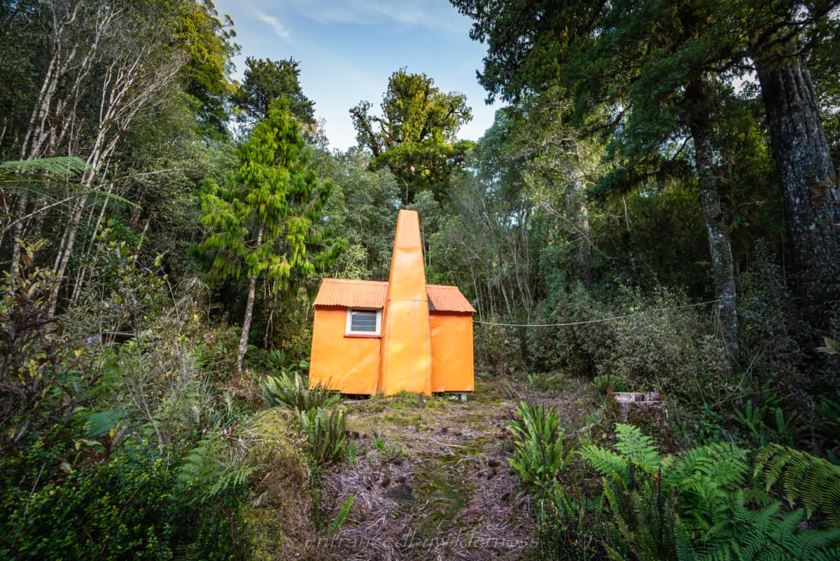
Newton Bivvy was my favourite hut – so isolated and small!
Many hiking route options in the area – this was one of many loops possible
Cons:
Not a lot of variety once on the Styx River
Frequent trail damage on the Styx River – becomes an eyesore after a while
Did the trip go to plan?
Not really. The main plan was a far longer route. Wasting half a day retrieving my ice axe (then losing hat/sunglasses anyway) restricted the time I had, and I was not doing a snow section without eye protection.
What would I change?
I underestimated how long it would take to traverse the ridge line between Mt Brown Hut and Newton Range Bivvy, I would have left earlier to help find the bivvy faster. I think I’d ensure I planned better to ensure I had time to go over Lathrop Saddle next time, and not head out the Styx River. However, it did make for a good shorter option in the end.
Did I achieve any personal goals of objectives?
No, although the vegetated ridge climb being quite hard and slow made me appreciate that I need more time with sections like this in the future.
Was I happy with my gear choices?
I was prepared for the snow, but I didn’t end up needing any of it on this trip, however it was quite clear on Lathrop Saddle the snow gear was going to be needed. I think also having some tough leather gloves for holding on to the shrubs and bushes would have been a good addition.
Your Donation Really Helps!
In order to support the travelling and hiking community, I spend many hours per week or month to adequately document all information and advice for prospective visitors, accompanied by a (hopefully) entertaining insight into my personal experiences. This service is, and will remain, free. However, running a non-profit website and spending time creating content comes with financial and personal costs.


Looks like an amazing time Matt! Looking forward to getting back to NZ one day in the near future and attempting some of these gnarly hikes!
Cheers guys! Let me know when you’re back and we could sync up one together!